The purpose of this function is to automatically generate the framework plan by applying the setback rules that are associated with road network classes, height restrictions, floor numbers, and floor heigh.
In this function we have three pages, which are basic, ruleset, and constraints.
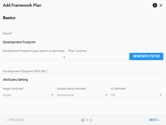
Basic
In this page, you can assign a name to the framework, select one envelope footprint as the base of the framework plan. Also, we need to assign the height attribute to generate the extruded 3D envelope boundary, name and ID attribute to identify different envelope boundaries.
| Parameters | Description |
|---|---|
| Name | Framework plan name |
| Developement Footprint | |
| Development footprint layer | An area that defines the outermost part of a site that a building can occupy (2D). This field allows users to search development footprint layer through digital twin, and choose a proper one for the framework plan |
| Filter condition | Standard CQL (Common Query Language) filter can be applied to the layer |
| Development footprint WFS URL | WFS link |
| Attribute Setting | |
| Height attribute | The attribute that has the height restriction value of each development envelop |
| Display Name Attribute | The attribute that has the name of envelope |
| ID Attribute | The attribute that has the unique ID of envelope |
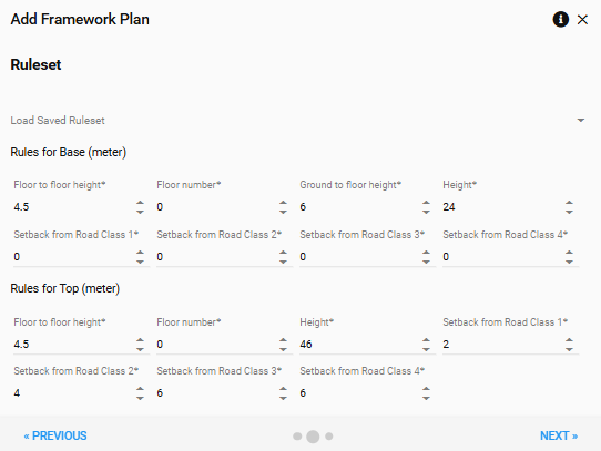
Ruleset
A set of specific rules controlling how the building blocks should be generated, including: base height, base setback, number of base floors, top height, top setback, number of top floors, number of total floors, etc.
You can either load the ruleset from the saved ruleset list or modify the ruleset parameters to create your own ruleset. For more details of the ruleset please visit the page: DEC Control Rulesets
Constraints
The purpose of road network constrains is to identify the edges of envelopes that are facing to the road and help to apply specific setback rules to these edges.
| Parameters | Description |
|---|---|
| Road network layer | |
| Road network layer (search by keywords) | This field allows users to search road network layer in the digital twin system, and choose a proper one for the framework plan |
| Road network layer WFS URL | GeoServer WFS link |
| Road buffer field | The attribute that has the value of road buffer |
| Road buffer within ratio threshold | If the proportion of an envelope’s edge that is within the road network buffer that is higher than this ratio, then this edge will be marked as facing the road. |
| Road class | |
| Road Class field | The attribute that has the value of road class |
| Road Class 1, 2, 3, 4 | The specific value of road class |
Save Framework Plan
After clicking the saving button, you will enter the framework plan edit mode. For more information about the edit mode, please go to the page Edit Framework Plan